About Canmore weather
Canmore experiences a mountain weather climate. The weather can change very rapidly from minute-to-minute and day-to-day. In the Spring you can experience a day of warm temperatures (20°C) and wake up the following day with severals centimetres of fresh snow on the ground.
A cause of rapid winter temperature changes in Canmore is the Chinook wind explained below.
During the winter months the humidity is consistently extremely low and vistors to the area are likely to experience dry skin as a result. For an effective remedy, we recommend George's Cream which can be purchased from local pharmacists and selected stores.

Canmore experiences a high level of winter and summer sunshine. Most days the sun will make a showing for at least a part of the day. One property developer advertising condominums in the UK stated in their advert that Canmore has 330 days of sunshine per year. We're not sure where they obtained that statistic and their use of it was misleading, but it's possible that the sun does make a showing, however small, on that many days a year.
If you're planning a visit to Canmore, we've reproduced some historical weather data from Environment Canada to enable you to get an idea of what to expect.
Average and Extreme Daily Temperatures in the Canmore Area
The following figures give the daily average temperatures and the daily extreme temperatures for the Canmore area.
The figures are based on historical data collected in Banff. Since Canmore experiences similar weather to Banff they can be considered close enough.
| Month | Daily
Ave. (°C) |
Daily
Max. (°C) |
Daily
Min. (°C) |
Extreme
Max. (°C) |
Extreme
Min. (°C) |
|---|---|---|---|---|---|
| Jan | -9.3 | -4.6 | -14.1 | 12.2 | -51.2 |
| Feb | -6 | -0.4 | -11.6 | 14.7 | -45 |
| Mar | -1.4 | 4.5 | -7.3 | 17.2 | -40.6 |
| Apr | 3.5 | 9.5 | -2.5 | 25.6 | -27.2 |
| May | 8.1 | 14.5 | 1.7 | 29.4 | -17.8 |
| Jun | 12 | 18.5 | 5.4 | 33.3 | -3.9 |
| Jul | 14.6 | 21.9 | 7.4 | 34.4 | -1.7 |
| Aug | 14.1 | 21.3 | 6.9 | 33.9 | -4.5 |
| Sep | 9.5 | 16.3 | 2.7 | 31 | -16.7 |
| Oct | 4.4 | 10.1 | -1.3 | 26.5 | -27 |
| Nov | -4.1 | 0.2 | -8.4 | 16.5 | -40.6 |
| Dec | -9.2 | -5.1 | -13.3 | 12.5 | -48.3 |
Average Monthly Precipitation in the Canmore Area
The following figures give the average monthly precipitation in the Canmore area.
Again these figures are based on data collected in Banff.
| Month | Rainfall
(mm) |
Snowfall
(cm) |
|---|---|---|
| Jan | 2.9 | 34.1 |
| Feb | 1.7 | 29.3 |
| Mar | 2.7 | 28.1 |
| Apr | 12.6 | 22.5 |
| May | 44.3 | 17 |
| Jun | 59.8 | 1.8 |
| Jul | 54.1 | 0 |
| Aug | 60 | 0.2 |
| Sep | 37 | 5.7 |
| Oct | 13.8 | 19.8 |
| Nov | 4.4 | 32.3 |
| Dec | 3.1 | 43.2 |
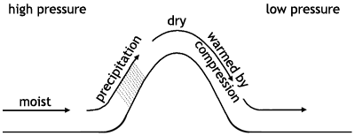
Chinook Wind (Foehen Wind)
Canmore often experiences what are known locally as chinook winds. These can rapidly change the temperature within a matter of minutes by as much as 20° Celsius.
These winds are caused by large-scale pressure differentials between the windward and leeward sides of mountain ranges. In the case of the Bow Valley, where both Canmore and Banff are located, a chinook can form when:
- high pressue is located over British Columbia
- low pressure is located over the Alberta prairies
- there's a moist, westerly prevailing wind across the divide from the Pacific
The diagram below shows schematically what occurs. The moist wind ascends the mountain range causing cloud buildup and most likely precipitation. When the flow of intense wind crests the mountain and begins to descend it dries and and warms due to compression. Because the descending air is dry (due to precipitation in the ascent) it warms significantly more on descent (1°C/100m) than it cooled during ascent (0.54°C/100m). In the case of Canmore, with surrounding mountains of 3,050 m (10,000 ft) and a valley floor of 1,370 m (4,300 ft) , the wind can potentially warm 17°C on the descent. Depending on the ambient temperature prior to the wind in the valley, the town will see a significant rise in temperature over a short period of time.